Featured Projects
Throughout the United States, 4-H youth, scouts, and K-12 classrooms have taken the lead - using GIS and GPS to study their localities and visually depict what they find.
This page gives a capsule summary of exciting youth projects.
Could youth near you create a similar project?
Projects listed by state

Youth GIS team members from Tennessee, Louisiana, New York and Maryland conducted the workshops that guided and inspired over 100 participants at the 2018 National Youth Health Summit to find, analyze, understand and take action to address significant health concerns in need of improvement. The material that they presented has been organized on a website that they created.
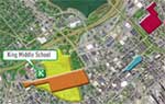
Students of King Middle School in Portland, Maine, created proposals on where trees could be planted in different neighborhoods in their community. To prepare for this, they surveyed residents about the benefits of urban trees, and later identified types of trees already present in the area. Their proposals were presented to city officials and community members.
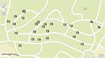
UME Talbot County 4-H volunteer, Cathy Cooper guides members of the Chapel District 4-H Club, plus the Director of the Historical Society of Talbot County, as they learn Geographic Information Systems for various types of map making. The club is creating a large historical map pinpointing schools and other points of interest within the town of Cordova. Their map will be featured in the Museum’s newest exhibit opening later this fall. Club members were also included in the planning process, color selections and painting of display walls.
Youth GIS team members from Tennessee, Louisiana, New York and Maryland conducted the workshops that guided and inspired over 100 participants at the 2018 National Youth Health Summit to find, analyze, understand and take action to address significant health concerns in need of improvement. The material that they presented has been organized on a website that they created.
The "Plant a Smile" 4-H club mapped the burial sites of Civil War soldiers in Newton Cemetery to celebrate the 150th anniversary of the Newton Civil War Monument. Two versions of the map were posted to allow the public to tour the sites.

In Massachusetts and Rhode Island 4-H SET is inviting community members to help gather information for their phenology mapping project. Learn more here.
A Fredricktown Boy Scout troop, after training with Frank Wideman, worked with local firefighters to map the town's nearly 300 fire hydrants. In an emergency, firefighters can access the map on their smartphones, shortening response times.
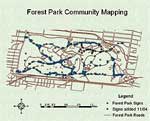
Over 300 4-H members attending the 2004 4-H Technology Conference partnered with the the City of St. Louis Department of Parks, Recreation, and Forestry to gather data on signs at Forest Park in St. Louis. In groups of 4-8 people, the 4-H'ers used cameras, GPS units and clipboards to gather information on their condition, material, distance from the curb, and any obstructions. Then the data was entered into a single database and put into ArcView before it was handed over to the Department of Parks, Recreation, and Forestry.
The GIS club of Lewistown Junior High School mapped sinkholes caused by old mining operations in their area. See their video here.
Students from Plymouth Regional High School worked with the New Hampshire Fish and Game Department to take water quality data in Baker River. Their data became part of a larger Watershed Education map for the state.

Andrew Wilson from Linwood, NH won an ESRI mapping contest with his story map about a logging railroad aain his hometown. The railroad had not been in use since 1916 and has since been reclaimed by nature. The map includes information about the histroy of the railroad and the Johnson Lumber Company that used it.
Shortly after Hurricane Sandy, students from Franklin High School launched a crowdsourced map of open gas stations in the New York-New Jersey area.
The IMSOCIO students not only identified broken and missing sidewalks in Franklin Township, with an emphasis on residential areas near Pine Grove Manor Elementary School and Franklin Blvd., but also identified uncontrolled intersections (missing stop signs and traffic lights) and crossing points without clearly defined crosswalks or crossing guards. They have documented and mapped all of those threats to safe travel, and will identify safe routes to school on the map by using a process of elimination.
Students in Trenton mapped their community to identify historic sites for tourist promotion, survey property condition for redevelopment, and perceptions of public safety.
In New York, 4-H clubs have worked with staff from two National Wildlife Refuges, Montezuma NWR in New York's Finger Lakes region and Target Rock NWR on Long Island, to map essential refuge resources.
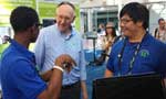
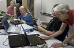
Members of the 2013 4-H Geospatial Leadership Team demonstrate to industry leaders, how 4-H youth are using Geospatial tools to improve the quality of decisions made in their communities.
Brandon Mathurin (left) did an interview for American Graduate Day.
16 final projects from the Spring 2015 session of GIS for International Crises, Development & the Environment at The New School for Public Engagement (NSPE). Projects include "Mapping Waste in NYC," "Mapping Seasonal Access for WFP in South Sudan," and "Mapping HIV/AIDS Vulnerability in Kenya" among others.
Youth GIS team members from Tennessee, Louisiana, New York and Maryland conducted the workshops that guided and inspired over 100 participants at the 2018 National Youth Health Summit to find, analyze, understand and take action to address significant health concerns in need of improvement. The material that they presented has been organized on a website that they created.
North Carolina
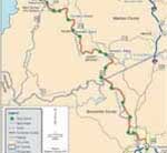
4-Hers mapped the Old Buncombe Turnpike and discovered the history of the old livestock-to-market route. They mined data from the state Department of Transportation and worked closely with the Madison County GIS Department.
4-H members in Wake County mapped out grocery and convenience stores and tracked those with healthy food options. Together with Advocates for Health in Action, they initiated a campaign to improve food selections in stores throughout the community. See the video.